
Mirandaverktyget
Välkommen till sidan för Mirandaverktyget, ett beslutsstöd för hållbart turismresande och infrastrukturplanering. Denna sida ger information om historik och bakgrund till verktyget samt information om det pågående projektet Miranda 2.0 där verktyget förfinas och utvecklas för att kunna komma till en bredare praktisk användning.
Här nedan visas den senaste utvecklingen för några av de ingående delarna.
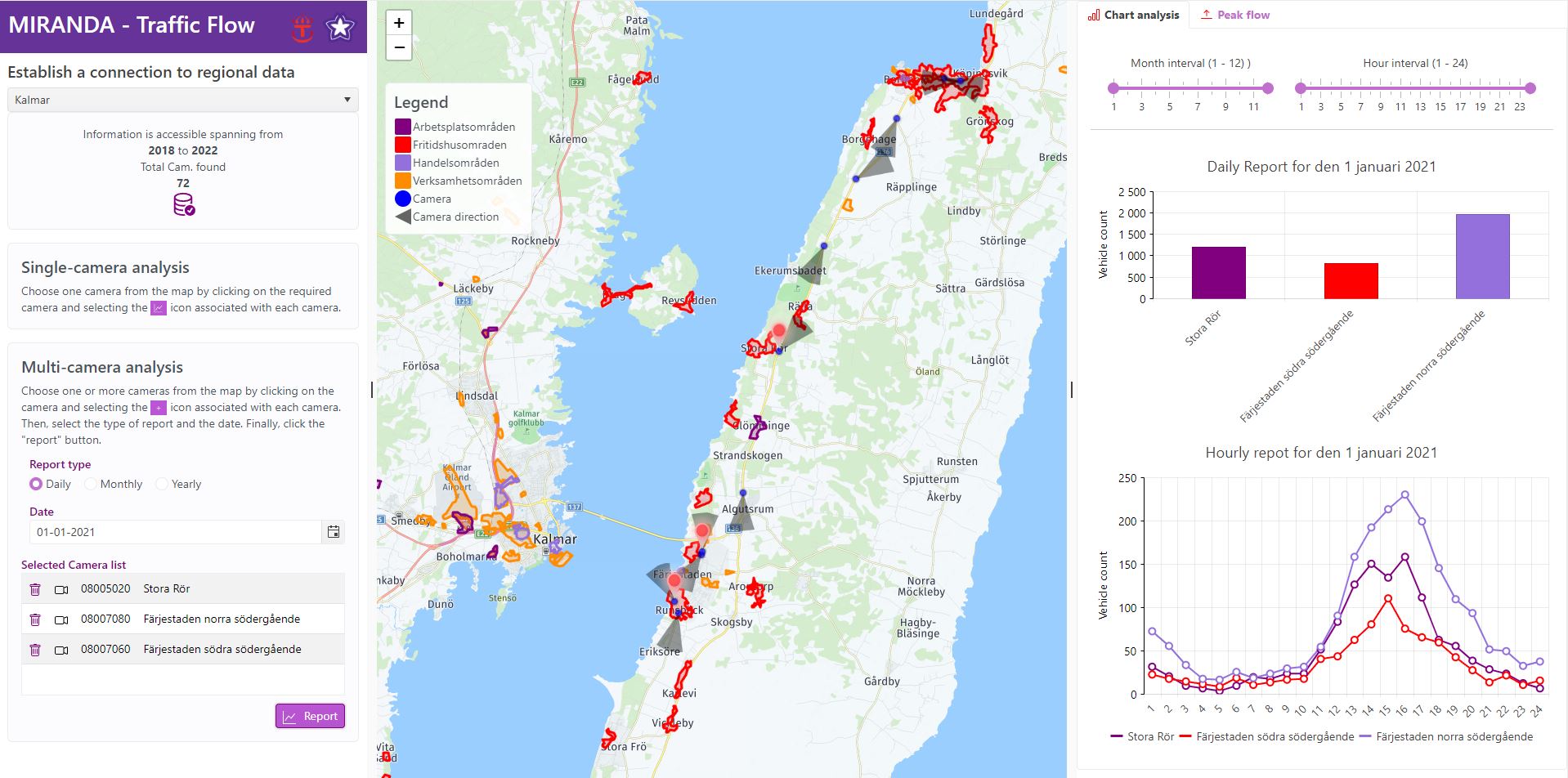
Traffic Flow Model
Tool for monitoring and analyzing traffic patterns across Sweden. By leveraging data from safety cameras, this tool provides detailed insights into traffic flow, allowing for analysis on both individual and multiple cameras simultaneously.
Whether you're looking to improve traffic management, enhance road safety, or optimize urban planning, the tool is an essential resource. Experience smoother traffic flow and safer roads with the Traffic Flow Analytics Tool, designed to support smarter, more efficient transportation systems throughout Sweden.
Go to the tool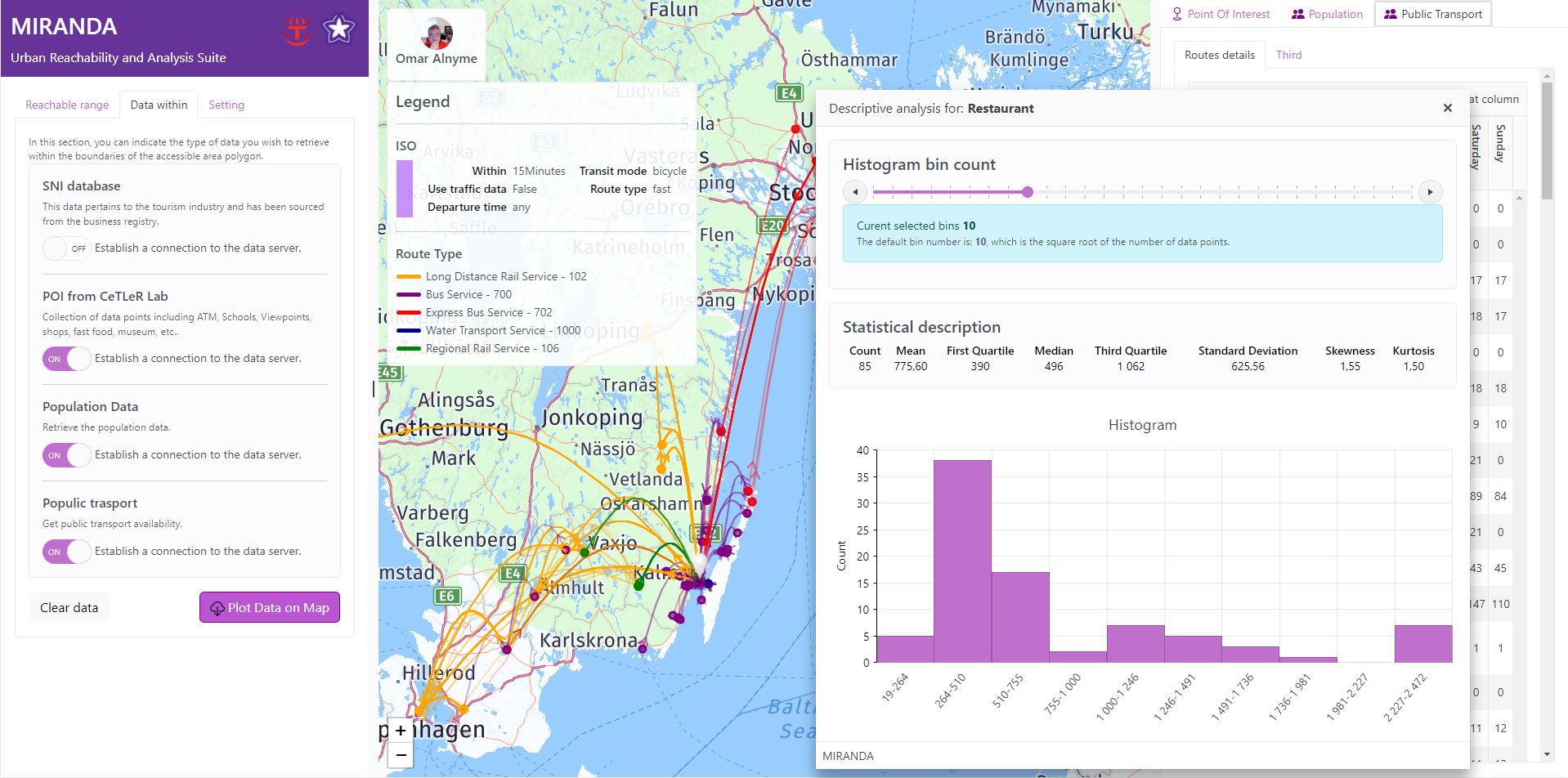
Urban Reachability and Analysis Suite (URAS)
Designed to enhance urban mobility and planning. URAS provides a range of features, including:
Isochrone Maps: Generate detailed maps to visualize areas reachable within specific time frames using various transit modes.
Population Analysis: Examine demographic data within the reachable range to understand population distribution and density.
POI Insights: Identify and analyze key points of interest within the accessible area, such as schools, hospitals, and shopping centers.
Public Transport Accessibility: Evaluate public transport options and determine reachable destinations from the defined polygon.
Go to the tool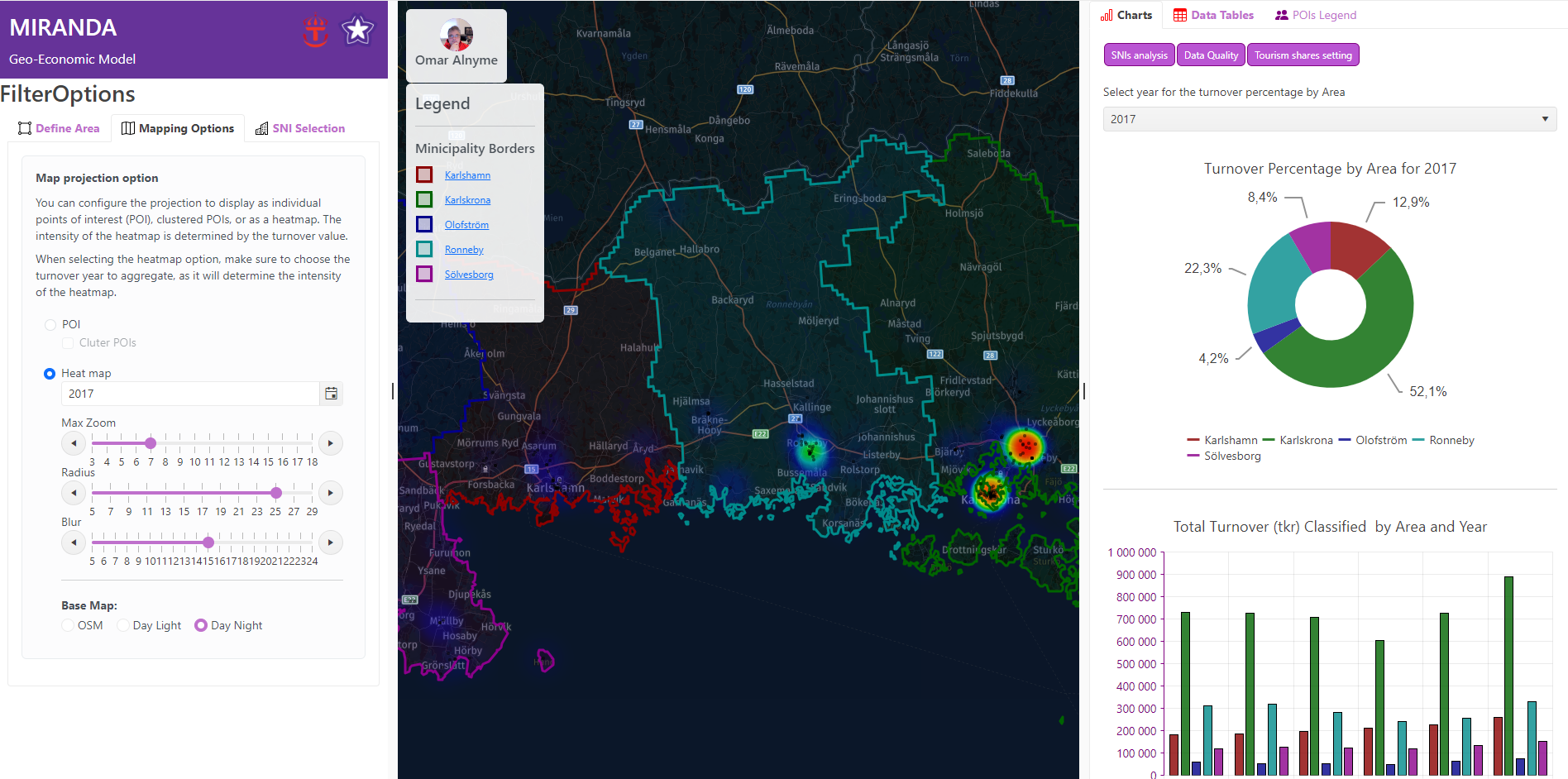
Geo-Economic Model
The Geo-Economic Model is a versatile tool designed to allow users to define and analyze specific geographic areas for economic study. Users can select a study area by choosing a municipality, drawing a custom region on the map, or utilizing reachable range analysis with various modes of transportation. Once the area is selected, the tool imports all tourism-related businesses within that region and offers multiple mapping options, such as cluster and heat maps, to support economic analysis.
In addition, it provides key metrics like total turnover, employee count, growth rates, and revenue per employee for the selected areas, enabling a comprehensive evaluation of the local economy.
Go to the tool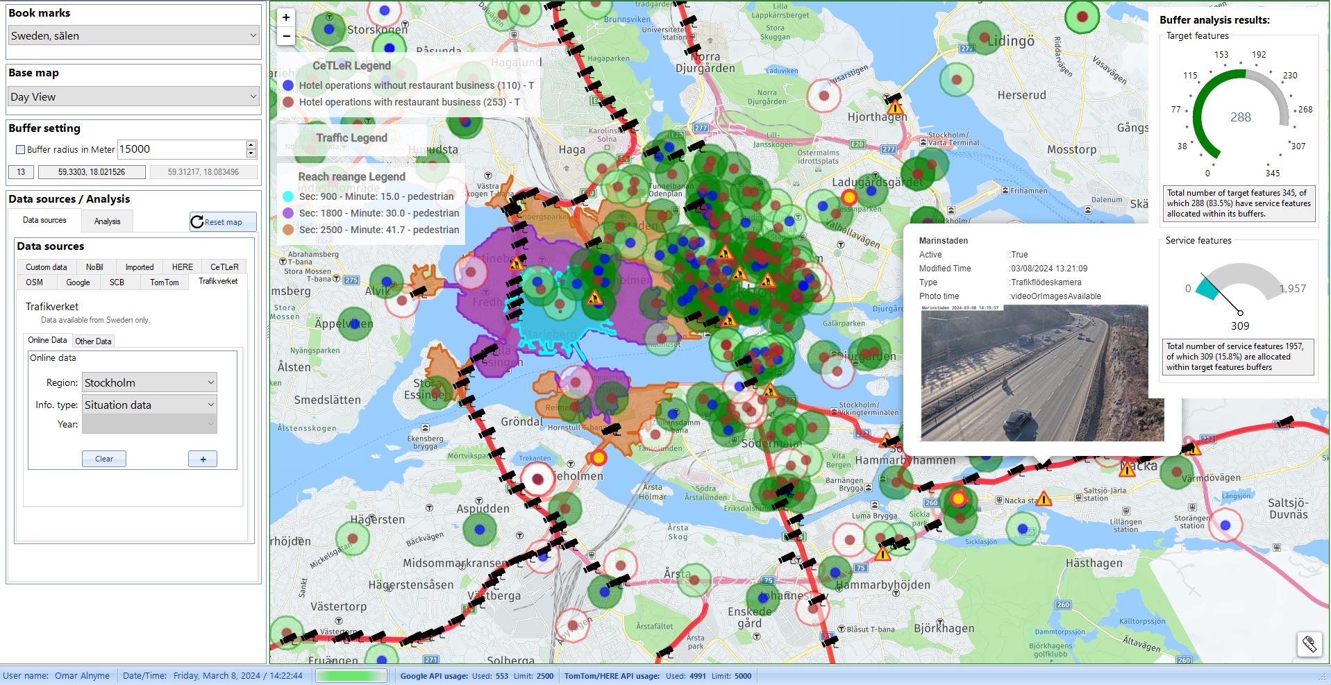
Spatial analysis model
Introducing the spatial analysis model capable of examining various points of interest (POIs) with precision. This tool offers a range of analyses, including buffer analysis, grid analysis, population analysis, route analysis, and public transport analysis. POIs are sourced from diverse databases, including the Cetler Lab database.
The benefits of such a tool are multifaceted. Firstly, it enables detailed examination of spatial data, aiding in urban planning, resource management, and infrastructure development. Secondly, by offering diverse analyses, it provides a holistic view of the spatial landscape, facilitating informed decision-making for policymakers and stakeholders. Additionally, the integration of POIs from multiple sources enhances the accuracy and richness of the analyses, leading to more effective strategies and interventions. Overall, this spatial analysis model serves as a valuable tool for optimizing spatial planning and fostering sustainable development.
under development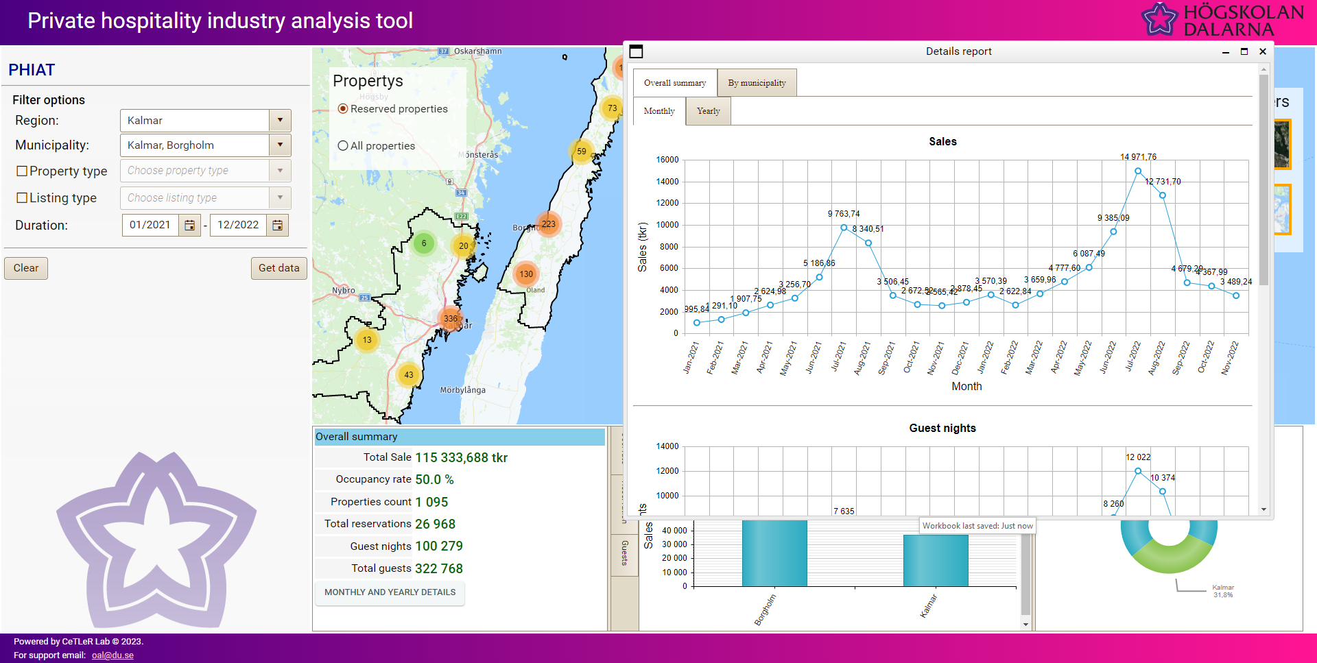
Private Hospitality Industry Analysis
The private hospitality industry is a vital part of the economy.
In order to conduct an effective analysis of this industry, unsupervised algorithms were developed.
The developed algorithm works on scraped data gathered from different online booking systems, the algorithm was embedded into a custom-developed online BI tool, and the result is a BI tool that helps businesses and municipalities gather valuable insights and gain a competitive edge in their industry.
The tool provides a yearly and monthly overall analysis of the selected municipalities, and individual analyses for each selected municipality:
- Total sales.
- Occupancy rate.
- Property count.
- Total reservation.
- Booked nights.
- Total guest nights.
- Etc..
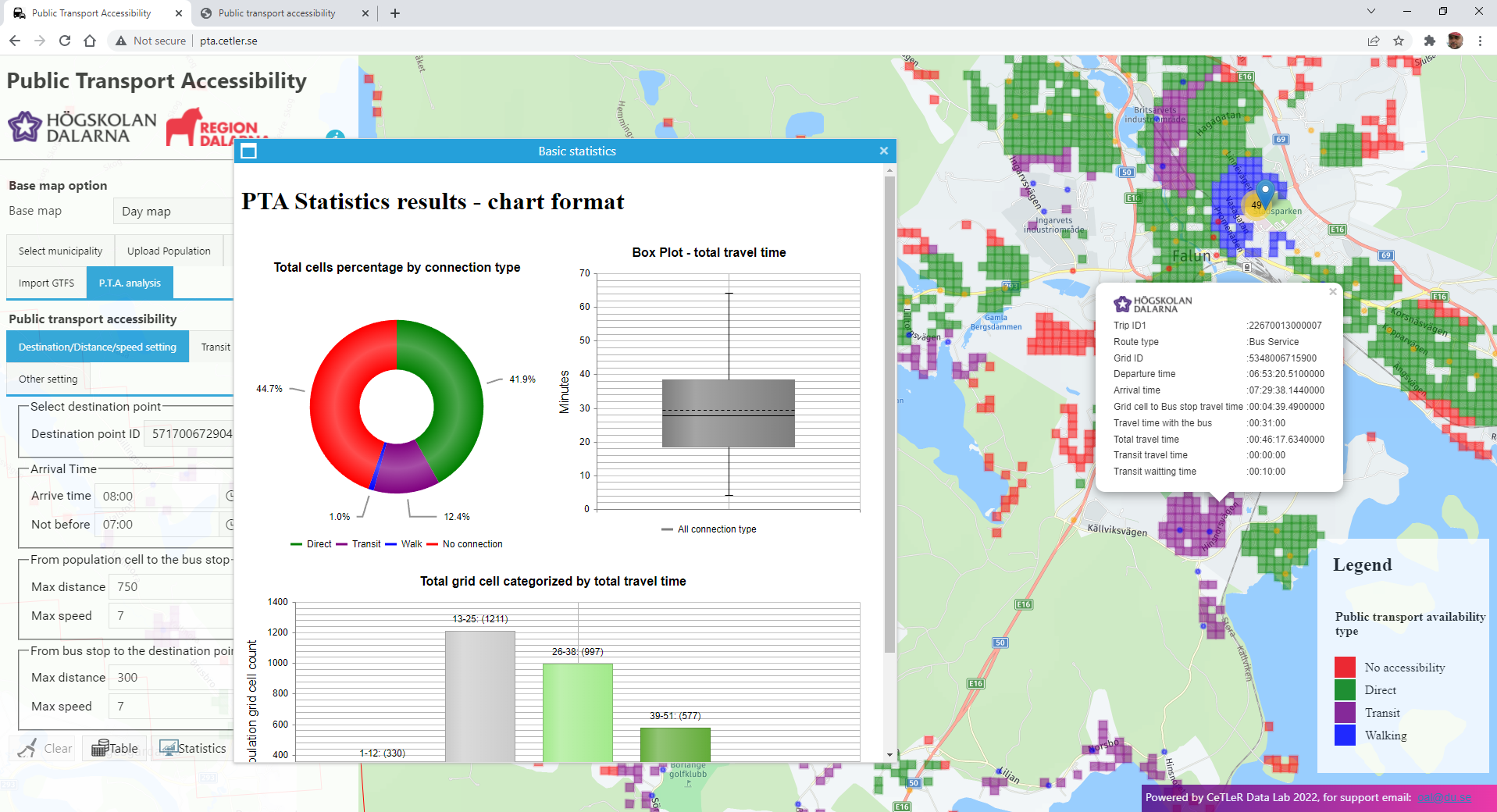
Public Transport Accessibility Analysis Tool
The transportation system's impact on accessibility is paramount, significantly influencing life satisfaction, particularly through public transport accessibility.
This tool utilizes unsupervised machine learning to identify population grid cells capable of reaching specific destinations within predefined time frames. Each grid cell is enriched with essential information, including arrival and departure times to the destination, travel times to the nearest bus stop, bus travel times to the destination's closest stop, and journey details such as trip ID, route ID, and trip type (direct or transit).
The results are presented both as a geospatial layer and in tabular format, facilitating seamless integration into statistical analysis software like R. Additionally, the tool offers basic statistical insights, empowering urban planners, transportation engineers, and policymakers to make informed decisions for enhancing public transport accessibility and promoting inclusive communities.
under development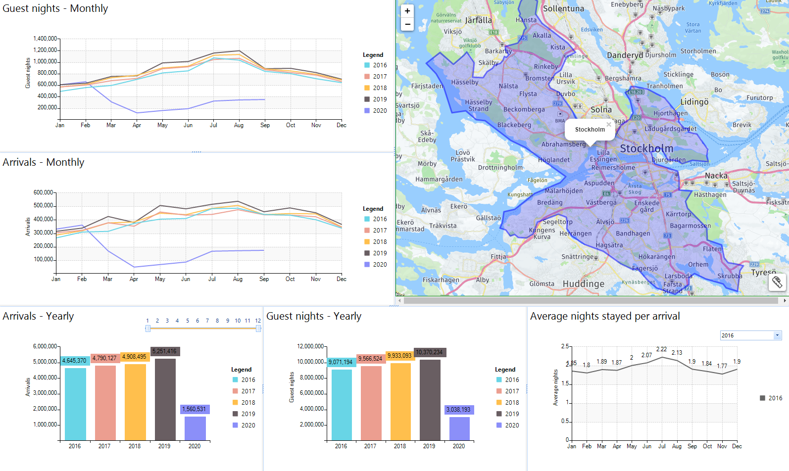
Tourism Volume
Analytics tool leveraging data from hotels and sewage systems to offer valuable insights into tourism activity. By amalgamating information from these diverse sources, the tool facilitates analysis at the municipality level, providing key metrics such as guest nights, guest arrivals, and average booked nights per arrival
under development